
Current Projects
The following projects are being undertaken between May 2026 and September 2026.
Tracking the Food Agenda: What Parliament Says About Food Across the Decades
In partnership with The Food Foundation.

Food policy spans across areas such as public health, national security, environmental sustainability and economic resilience. Yet how policymakers talk about food, which risks they prioritise and which they overlook, remains poorly understood. Hansard, the official record of all UK parliamentary proceedings, offers one of the richest records of political concern but its scale makes it difficult to analyse systematically. Recent research applying natural language processing to parliamentary debate has shown that large-scale text analysis can uncover long-term shifts in political rhetoric that would otherwise go unnoticed.
This project will apply natural language processing methods, including topic modelling and sentiment analysis, to UK Parliament’s Hansard transcripts. Working with debates spanning several decades, a methodology will be developed to automatically identify food-related discussions and explore the issues raised within them. Topic modelling will be used to identify recurring areas of discussion, while sentiment analysis will help examine how food issues are framed and debated across different political periods and in response to major real-world events.
The project aims to map the changing landscape of food policy discourse within UK Parliament, identifying emerging and diminishing areas of concern across the food system. An openly available codebase will be produced to allow for application to other policy domains. Together, these outputs will contribute both a substantive analysis of food policy discourse and a reusable methodological framework. Findings will be developed into policy-relevant outputs in collaboration with The Food Foundation, supporting evidence-based advocacy and parliamentary engagement.
By Molly Sargent
Spatial Dynamics of Crimes
In partnership with the ESRC Vulnerability and Policing Futures Research Centre, Connected Bradford and Healthy Urban Places (HUP)-North.

Schools sit at the heart of community life, providing the places where children and young people learn, build friendships, and develop. They are also among the busiest sites in any neighbourhood, drawing pupils, families, and staff in and out across the course of the day. Criminological studies have shown that places with high levels of activity tend to experience more crime, driven by the increase in potential opportunities as more people interact. This implies that schools may be at elevated risk, given the volume of people they draw into the neighbourhoods surrounding them. These areas have the potential to become hotspots for crime, exposing residents, school staff, and students to elevated risks. These hotspots may have particularly harmful effects on children and young people who, by virtue of their age, may be vulnerable to being either victims or perpetrators of crime, while also experiencing impact on their ability to continue to access education safely. This project aims to quantify the extent to which schools are associated with elevated risks of crime and police demand, and to understand how these risks vary spatially, temporally, and between institutions. In doing so, it aims to provide new ways to strengthen the decisions schools, police, and partner agencies make about safeguarding, attendance, wellbeing, and prevention.
The project focuses on secondary schools in the Bradford region of West Yorkshire, which is a diverse district with both urban and rural settings that provides a rich and policy-relevant context for this investigation. Open datasets from OpenStreetMap and the UK Government's Get Information About Schools database will be used to extract school locations, along with their characteristics. These will be integrated with crime data from two sources: open data accessed via the Police.uk platform, and records from West Yorkshire Police, accessed through the secure Connected Bradford Research Database. The volume and rate of crime occurring around schools will be calculated using a variety of methods. Spatial buffers will be derived across several scales and will use both Euclidean and network-based (i.e. measuring distance via the street network) approaches. By applying these methods, we will construct detailed profiles of how risk varies by distance, time, and neighbourhood characteristics relative to school locations.
Findings have the potential to inform a range of prevention and support strategies. A clearer understanding of how crime concentrates around school can help guide early intervention strategies such as safeguarding decisions, attendance and wellbeing strategies, and place-based prevention investment. Insight into how these patterns vary spatially – whether directionality can be anticipated, and whether they track other types of activity – can in turn support policing and safe route planning for pupils. The analytical workflows developed in this project can be scaled across other urban districts, contributing to a broader national evidence base on the relationship between schools, neighbourhoods, and young people's safety.
By Emeka Onyebuchi Enechukwu (Buchi)
Evaluating inequalities in access to healthy food through the Digital Food Retail Environment
In partnership with Nutrition North and the Office for Health Improvement and Disparities (OHID).

This project investigates how the rapidly expanding Digital Food Retail Environment (DFRE), including grocery delivery services and online takeaway platforms, is reshaping access to affordable and healthy food across Great Britain. The research explores whether the DFRE entrenches existing inequalities linked to diet, obesity, and food insecurity between neighbourhoods.
Using web-scraping and spatial data analysis, the project will build a new neighbourhood-level database capturing the availability of ‘ondemand’ online groceries and takeaway food across more than 41,000 neighbourhoods in Great Britain.
These data will be combined with indicators of neighbourhood composition and characteristics, indicators deprivation and health outcomes to investigate spatial inequalities in access to ‘on-demand’ food access and their relationship with diet-driven public health challenges. The study will also begin to explore whether healthier food options are less affordable or accessible in some neighbourhood types. Alongside the national analysis, the project will conduct detailed spatial and temporal studies in selected cities within Yorkshire and the Humber.
The project aims to establish a scalable and compliant web-scraping methodology for capturing the DFRE at a national scale, while generating new evidence on inequalities in digital food access. The resulting database and framework will support future research and policy development relating to healthier and more equitable food systems.
By Chenrui Xiao
Spatial and Ecological Evaluation of Developing Spaces (SEEDS)
In partnership with Hyde Park Source and FoodWise Leeds.

Global soil degradation poses a critical challenge to future food security, with the Food and Agriculture Organization of the United Nations (FAO) estimating that 33% of soils are already degraded and over 90% may be at risk by 2050. As pressure on agricultural systems intensifies, cities are increasingly recognised as sites for food production. Community Growing Schemes (CGSs), including community gardens, allotments and informal urban agriculture, represent a key strategy to diversify and localize food production and utilise underused urban land.
Often led by grassroots groups, CGSs improve food security by increasing access to healthy, sustainable and affordable food, particularly for food insecure populations. They strengthen resilience to supply chain disruptions and support more democratic, local food systems.
Beyond food provision, CGSs deliver wide-ranging social, economic and environmental benefits including: building community relations, increasing food literacy, supporting public health and encouraging waste recycling. Urban green spaces also provide ecosystem services, such as nutrients and organic carbon storage.
As urban soils are subject to numerous diverse anthropogenic activities, they may have high levels of pollution, posing risks to human and ecological health. Despite this, data on soil health and CGSs remain fragmented, limiting the ability to assess safe growing areas and target interventions.
This project, in partnership with Hyde Park Source and FoodWise Leeds, aims to assess and enhance the impact of CGSs in Leeds through spatial and statistical analysis. Using open-source socio-demographic and environmental datasets, the project will evaluate existing data, improve accessibility, identify areas for soil health interventions and determine suitable sites for new CGSs.
By improving reproducible data integration and accessibility, this research will support evidence-based urban planning, reduce exposure to contaminated soils, and promote sustainable land management. Ultimately, the project aims to strengthen local food systems, inform policy and contribute to healthier and more resilient urban communities.
By Marion Carneiro
Longitudinal Biomarker Trends in Multiple Myeloma Patients During Treatment and Impact on Outcomes
In partnership with with UK Myeloma Research Alliance and Haematological Malignancy Research Network.
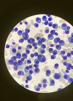
Multiple myeloma is a blood cancer affecting plasma cells in the bone marrow, leading to abnormal protein production, bone damage, and impaired blood cell formation. While treatments have improved significantly in recent years, the disease remains incurable and patients experience cycles of response and relapse that vary widely between individuals. Understanding why some patients respond deeply to treatment whilst others experience poor outcomes, particularly in relapsed and refractory disease, remains a critical challenge in myeloma care.
This project analyses longitudinal biomarker data from the Myeloma XI trial, a large UK Phase III adaptive randomised controlled trial that enrolled over 4,000 patients across more than 100 NHS hospitals between 2010 and 2016. Biomarkers including paraprotein levels, serum free light chains, and beta-2 microglobulin serve as measurable indicators of disease activity and treatment response. By tracking how these markers change over time across different treatment pathways, we can identify patterns that distinguish patients who achieve sustained remission from those who relapsed.
Using statistical methods including longitudinal trajectory modelling, mixed effects regression, Kaplan-Meier survival analysis, and Cox proportional hazards modelling, this project will describe how biomarker trends differ across treatment pathways, examine whether patient characteristics at diagnosis such as disease stage and genetic risk influence these trends, and assess whether the pattern of biomarker change predicts long-term outcomes including progression free and overall survival.
The findings will be translated into an interactive clinical dashboard, enabling clinicians and researchers to explore biomarker dynamics visually and apply insights directly to patient care and future trial design.
By Damilola Ogungbemi
Visualising Seasonal Variation of Environmental Impact from Food Purchases in the UK
In partnership with a Major UK Supermarket Retailer.

Understanding diet at the population level is often limited to a single point in time, such as a diet recall or survey taken at one timepoint. Supermarket transactions present a novel and rich source of data that can be used to understand how dietary behaviours change over time. Although supermarket transaction data have been increasingly used in studying food purchasing behaviours, less is known about how the environmental profile of what we buy changes across the year.
This DSDP project builds on the FIO Food project, which represents a dataset of hundreds of millions of product sales held within the LASER secure data environment at the University of Leeds. Working with daily sales data from the retailer, covering the whole of 2022, the dataset links environmental and nutritional data with an aim to explore seasonal variations in environmental sustainability of food purchases across Yorkshire and the Humber, with a possible extension to UK-wide coverage.
Our goal is to analyse environmental sustainability of real-world sales records to produce daily estimates of environmental footprints. We aim to track how these footprints shift over time, such as around key public holidays and cultural events. Identified findings can help in highlighting opportunities for more sustainable food choices and informing target periods for in-store interventions that nudge shoppers towards low-impact alternatives.
This interdisciplinary collaboration, combined with direct engagement with the retail partner, reflects the project's ambition to produce findings that are relevant, not just to academic audiences but to industry and policymakers. The data product from the project is expected to be made available through the Healthy and Sustainable Places Data Service (HASP), and aims to provide insights that can shape national and retailer-level policy to improve planetary health, further advancing LIDA’s mission of applying data science to real-world problems for public good.
By Piyush Mohan
Patterns of Antimicrobial Resistance: A community-level study of Dhaka, Bangladesh
In partnership with the National Institute of Neurosciences & Hospital and Jahangirnagar University.

Antimicrobial resistance (AMR) is one of the top global health challenges according to the World Health Organisation. In Low- and Middle- Income Countries (LMICs), antibiotic use is often high-volume yet inconsistently regulated. Multiple factors contribute to this, including higher baseline burdens of infectious disease, economic pressures that limit people’s ability to take absence from work when ill, widespread use of broad-spectrum antibiotics, and informal access to antimicrobials. As a result, AMR-related mortality in LMICs is significantly higher than in many other parts of the world.
Bangladesh represents a particularly important setting for AMR research due to dense human–animal–environment interactions, high rates of infectious disease, and rapidly growing livestock production, which create conditions favourable for the emergence and spread of AMR.
Investigating microbial profiles using whole genomic shotgun sequencing data alongside lifestyle and behavioural factors collected through qualitative surveys, our aim is to characterise patterns of AMR within communities in Dhaka, Bangladesh, and to understand how antibiotic use, diet, lifestyle, socioeconomic conditions, and behavioural factors shape the gut microbiome and resistome over time. Importantly, the project adopts a ‘One Health’ perspective, recognising the interdependence of the social, environmental, and biological dimensions of this challenge.
We are partnering with the National Institute of Neurosciences & Hospital and Jahangirnagar University, whose teams have contributed to participant recruitment, data collection, and local contextual expertise throughout the project.
Using established metagenomic analysis pipelines, we will conduct taxonomic and functional profiling of the gut microbiome and characterise resistance genes. This will then be integrated with qualitative and socioeconomic data using multivariable statistical modelling to identify associations between AMR and cultural, dietary, behavioural, and environmental factors.
The findings are expected to contribute to a deeper understanding of both the biological and behavioural drivers of AMR in Dhaka, Bangladesh and other LMICs. Ultimately, this work aims to support more equitable antibiotic regulation, community-informed public health interventions, and evidence-based AMR mitigation strategies.
By Emma Briggs
Educational Impacts of Transport and Geography
In partnership with Bradford Institute for Health Research.

Using data from schools across Bradford this project examines the connections between where students live, their journeys to schools and their academic achievement. This includes factors such as attendance, attainment and exclusions. Recognising that the "geography of opportunity" is rarely evenly distributed, the project considers whether students are systematically disadvantaged by a lack of viable travel options to and from school, potentially imposing a "spatial penalty" on their educational success.
Facilitating this analysis is a vast dataset provided by Bradford Institute for Health Research comprising information about individual pupils from every school in Bradford, paired with their approximate home address.
Examining student journeys to school by foot, car and public transport allows for identification of areas where pupil performance may be impacted by being poorly served by current transport infrastructure.
The insights generated by this work provide an empirical baseline for implementing interventions to mitigate inequalities in education access.
By Hal Kolb