New Machine Learning Method Uses Physics to Image Earth's Interior
A physics-informed neural network (PINN) is a type of deep learning framework that incorporates physical constraints or relationships into its architecture. Traditional neural networks are based solely on data, using machine learning to find statistical relationships. PINN combines this data-driven machine learning with physics-based modelling. It shows great potential in high-performance seismic imaging of the Earth's interior. Solving inverse problems via PINN formulations is solving a joint state and parameter space estimation problem.
We present a novel eikonal tomography approach using PINNs (pinnET) for Rayleigh wave phase velocities based on the eikonal equation-describes the local direction of propagation of seismic wavefronts. pinnET utilizes deep neural networks as universal function approximators and extracts traveltimes and velocities of the medium during the optimization process (Figure 1). Whereas classical eikonal tomography uses a generic non-physics-based interpolation and regularization step to reconstruct traveltime surfaces, optimizing the network parameters in pinnET means solving a physics constrained traveltime surface reconstruction inversion tackling measurement noise and satisfying physics. This approach overcomes limitations in conventional seismic imaging methods to achieve high resolution at low computational cost.
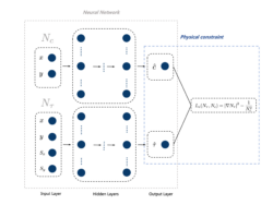
Figure 1: PINN framework for ambient noise eikonal tomography.
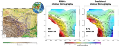
Figure 2: (a) Overview of the station network in Tibet; (b) The predicted 25s phase velocity map using pinnET; (c) The 25s phase velocity structure generated by conventional eikonal tomography.
We extract Rayleigh wave phase velocities at 25s period from ChinArray II, a dense seismic array sampling the northeastern Tibetan Plateau, to train the pinnET neural network (Figure 2). We restrict the number of sources used in our approach to 10 sources recorded at all 676 stations of the network compared to all source-receiver combinations common in other methods. Validation of pinnET results against conventional eikonal tomography models for the same area confirms the new method's ability to reveal phase velocity structure. pinnET requires less data and computational recourses but achieves at least similar accuracy and resolution. Overall, pinnET opens new possibilities for gaining insights into complex Earth systems. By bringing the power of machine learning to geophysical imaging problems, the method achieves computational efficiency and accuracy that could significantly improve understanding of subsurface structures.