Volcano Monitoring
Measuring volcanic deformation from space to enable global monitoring
Volcanic eruptions are obviously problematic, not only presenting danger to life but also posing significant economic impacts. Some volcanoes have dedicated volcano observatories staffed by experts ranging from seismologists to traditional geologists and people who analyse gas. In some cases, they will be working with satellite remote sensing data. However, about 90% of land volcanoes aren’t really monitored.
This complex data modelling work by Leeds’ research fellow Dr Matthew Gaddes and Professor of Geodesy and Geophysics, Andrew Hooper, is a 5-year EU funded project looking at the correlation between volcanoes that deform and erupt using radar interferometry. The original work was funded by NERC (through the LiCS and COMET grants) and continuing work is funded by the ERC (DEEPVOLC grant), ESA (Living Planet Fellowship) and NERC (COMET). The overall aim of the work is to detect and also forecast volcanic deformation from space to enable global monitoring.
An algorithm they built, LiCSAlert, looks for volcanic unrest by detecting changes in deformation, either as a change in rate of deformation, or a change in style that would indicate that someone needs to go and look at that volcano.
The work makes use of InSAR (Interferometric Synthetic Aperture Radar) data, which reports ground deformation using radar images of the Earth’s surface which is accurately measured, within centimetres and millimetres.
“The European Space Agency has revolutionised InSAR data by making it freely available,” explains Dr Gaddes. “Before you might get some data, but you could never get access to all of it. Now thermal anomalies can be identified from satellite data imaging the Sulphur Dioxide (SO2) erupted into the atmosphere.”
Much of the work stems from the European Space Agency’s Looking Inside the Continents from Space (LiCS) project. Looking inside the Continents from Space with Synthetic Aperture Radar (LiCSAR) is an operational system built for large-scale interferometric processing of Sentinel-1 data, combining pairs of images to make interferograms. LiCSAR automatically produces geocoded interferograms and coherence estimates for large regions, at 0.001° resolution, continuously updated at a frequency that depends on prioritised regions (a monthly, weekly, or live update strategy). The products are open and freely accessible, downloadable through an online portal.
LiCSBAS, an open-source Python package developed by Japanese researcher in Geodesy, Yu Morishita, when he was at Leeds between 2018 and 2020, uses LiCSAR to construct a time series analysis from the interferograms. The LiCSAlert algorithm then uses these time series to look for changes in deformation to detect volcanic unrest, primarily for change in a time series.
“Because our algorithm looks for change, we tend to look for volcanoes that have a change in deformation, because it’s not particularly interesting if a volcano is deforming at a very steady state. There are examples of volcanoes that deform for years and years and years,” explains Gaddes. He adds that the algorithm isn’t designed to replace humans, that it’s a long way from being better than a human expert, but that with more than 1,000 sub aerial volcanoes around the world that aren’t being monitored, many of them in poorer countries, this provides a scalable solution. “We’ve built an algorithm that looks for change in the rate of deformation, or a new style of deformation. We provide a way of sifting through a vast amount of data, enabling us to focus and say, go and look at that volcano this week because something has changed.”
For the volcanoes that already have observatories with experts on InSAR, this tool will help them interpret the data, but the biggest impact being where volcanoes aren’t currently monitored. “The original paper https://agupubs.onlinelibrary.wiley.com/doi/full/10.1029/2019JB017519 was proof of concept – we are now rolling it out to apply this globally,” explains Prof. Hooper.
Currently LiCSAlert is monitoring between ten and fifteen volcanoes (the number fluctuates), with the next stage of the work being to roll it to hundreds of volcanoes. Of course, deformation of a volcano can be measured very accurately by simply sticking a GPS receiver at the volcano site. To monitor accurately a network of five or ten of them would be needed. And certainly, some Italian volcanoes do have 15 or 20 GPS receivers monitoring them. But this is not scalable. The costs to install and maintain ten GPS instruments would then need to be multiplied by the 1,350 volcanoes that could erupt globally, leading to an astronomical cost. This algorithm is hugely scalable, it rolls out with no extra cost (apart from a small amount of processing cost) from one volcano to one and a half thousand volcanoes.
“The ultimate aim with our algorithm is to see it have a really great impact on the day it picks up a volcano of consequence – with people living nearby or it being near flight routes – that nobody thought was deforming, but is,” says Dr Gaddes.
This work is a great example of multidisciplinary research and collaboration, and of models that can, and are be used in other fields. One of the key modules, deep down in the LiCSAlert algorithm, is a tool called Independent Component Analysis, which has been used in medical imaging to process fMRI data. The LiCSAlert model is also suitable for use with lots of different time series datasets when looking for changes. “If you had a webcam photographing a river, for example,” says Matthew Gaddes, “you could look for that same idea – anything that changes in a time series of images.”
There are also plans for future work relating to volcano monitoring. The image from the radar satellite is currently a simple black-and-white 2D image. Moving forward Gaddes and Hooper would like to add more data to the deformation measurements to create a time series of 3D data including the amplitude measurements and thermal anomalies. “We’re also working more now on deep learning, AI techniques to enable us to forecast what will happen, rather than looking at what is happening.” Adds Professor Hooper.
Further information:
Looking Inside the Continents from Space (LiCS) grant is funded by Natural Environmental Research Council (NERC).
Continuing work on this project is funded by a European Space Agency (ESA) Living Planet Fellowship and the European Research Council DEEPVOLC grant.
Data used is from a Copernicus mission, which is operated by the ESA and funded by the EU.
https://comet.nerc.ac.uk/comet-lics-portal/
The initial part of this work was published in 2020. More information can be found here: https://www.mdpi.com/2072-4292/12/15/2430.
Data generated can be found here: https://comet.nerc.ac.uk/comet-lics-portal/.
Email:
Dr. Matthew Gaddes & Professor Andrew Hooper
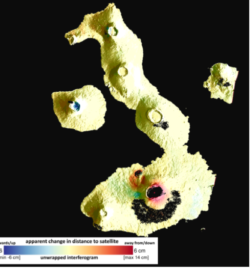
A 24-day interferogram that shows ~6cm of deformation at the southern volcano (red area).