Healthy Choices, Healthy Lives: The Local Food Environment – Holme Wood as a case study
This project developed a ‘proof of concept’ community toolkit to visualise food environment accessibility for a deprived community in Bradford, empowering local policymakers and residents to collaborate through evidence-based decision making.
Project overview
Obesity and other non-communicable diseases linked to sedentary lifestyles and poor diet are on the rise globally. Modern food environments play an important role in this and have evolved to promote choices that adversely impact people’s physical and mental health. These are described as being more obesogenic (obesity promoting) due to the relative ease with which unhealthy foods can be acquired, lacking essential nutrients and containing more energy than is necessary. The concept of food environments covers a wide range of physical, economic, socio-cultural and policy factors, one of which is the accessibility and affordability of retail food outlets. Communities experiencing high levels of deprivation are disproportionately impacted, facing barriers to mobility and an overwhelming choice of unhealthy and expensive food creating the perfect conditions for obesogenic food environments.
Holme Wood is one such community in Bradford and the focus of the ActEarly project. At a workshop last year, residents reported that their options for purchasing healthy, affordable food were limited. This project has mapped the local food environment and generated granular accessibility measures for small groups of households within the study area. These have been integrated into an interactive community toolkit for local stakeholders to collaborate in regeneration and intervention policies that are targeted at improving access to their food environment. This project is unique in that it generates accessibility measures at a more granular scale than existing research and combines it with open data in a ‘proof of concept’ interactive visualisation tool.
The toolkit can be accessed using the following URL: https://tbalbone31.shinyapps.io/lida1healthychoices/
Data and methods
We created food outlet accessibility measures for Holme Wood using Ordnance Survey Points of Interest (POI) data and postcode units. These data were chosen due to their detailed level of spatial granularity, which can often be a barrier when conducting localised spatial analysis.
POI data were cleaned and categorised using the same groups as the Food Environment Assessment Tool (FEAT) for consistency. The following groups were chosen to be part of the analysis:
Supermarkets: Major national supermarket chain stores (including small-format brands such as Sainsbury’s Local and Tesco Express/Metro)
Speciality Outlets: A wide range of outlets specialising in a narrow type of food produce, including (but not limited to) Butchers, Frozen Foods, Grocers, Markets and Baking/Confectionary.
Convenience Stores: Local convenience stores that can vary in types of food stocked but typically characterised by longer opening hours and food and drink from a broader range of categories than speciality outlets.
Takeaways: Fast food and takeaways outlets, delivery services, fish and chip shops and bakeries.
Access measures were drawn from a range of existing research and calculated using postcode units within the Holme Wood study area as an origin. As the area is urban, Euclidean (straight-line) distance calculations were used to establish travel boundaries. The following measures were used to determine accessibility to the food environment for each outlet type:
- Distance to the closest food outlet
- Mean distance to the closest 3 food outlets
- Mean distance to the closest 5 food outlets
- Count of outlets within 500m/1km/1.6km/2km
These measures were used to create a series of outputs at the postcode unit level. A neighbourhood level analysis was conducted looking at distribution of distance measures across all postcode units. Individual postcode unit measures were visualised within the community toolkit application.
Key findings
The neighbourhood level analysis is shown in the density plots below.
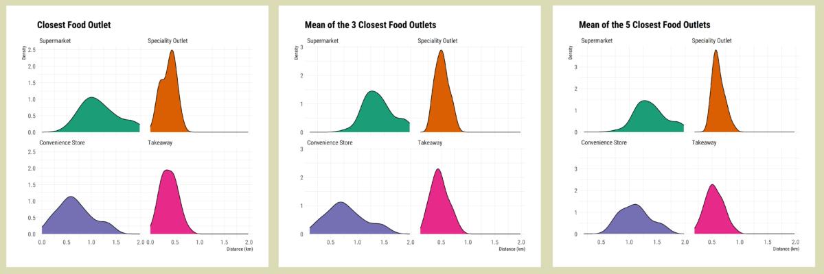
Each measure shows a similar trend, that supermarkets are more likely to be the least accessible outlet type for a large proportion of the area. On the other hand, Takeaways are much more likely to be within a relatively small distance across most of the neighbourhood. This intensifies when considering the mean of closest 3 and 5 outlets, where more choices within each group are being considered. There appears to be better access to Convenience Stores and Speciality Outlets, however the variety of food available and affordability at these outlet types can vary significantly (Black et al, 2014). Whilst there appears to be access to supermarkets and some other outlet types, this is varied across the area and overwhelmed by the density of takeaways right on resident’s doorsteps.
People who experience higher relative deprivation often face barriers to mobility, the consequences of which are that people in Holme Wood are likely to be more reliant on their immediate food environment than those who are less deprived. Further research is necessary into what choices are available in local outlets and whether this can be improved through work with community groups and policymakers.
Providing an interactive community toolkit that shows a more granular level of data visualisation is an important step towards empowering these groups to further understand the challenges communities face by including residents and other stakeholders in the decision-making process. To place the postcode measures in context, a range of existing datasets related to the local environment have been included. This toolkit also acts to signpost users to linked research.
Value of the research
The value of this research is that it takes existing approaches to calculating indicators of food environment provision and accessibility and applies it on a more local scale, providing information and evidence to key stakeholders using interactive visualisation tools and techniques. Whilst the output is a proof of concept and not necessarily a final solution, it can be used to start honest conversations between local policymakers and members of the communities that they serve and ensure everybody is working from the same information. It addresses a key aim of the ActEarly scheme to empower local communities using data science and analytics.
This toolkit could be expanded on and developed to service other communities and allow for future updates to datasets should the need arise.
Insights
- Holme Wood faces many of the same challenges accessing the retail food environment as other deprived communities.
- Food outlets that offer less variety in choice and affordability are a more convenient choice for residents.
- Whilst the food environment can be complex to understand, aspects can be visualised using tools that are accessible to key policymakers and stakeholders.
- Future studies could expand on the proof-of-concept toolkit by adding new functionality, improving accessibility measures or applying to different areas.
References
Black, C., Ntani, G., Inskip, H., Cooper, C., Cummins, S., Moon, G. and Baird, J., 2014. Measuring the healthfulness of food retail stores: variations by store type and neighbourhood deprivation. International Journal of Behavioral Nutrition and Physical Activity, 11(1), pp.1-11.
Research theme
Identify which research theme this sits under:
- Health informatics
- Urban analytics
People
Tom Albone – Data Scientist Intern (LIDA)
Dr Michelle Morris – University Academic Fellow in Health Data Analytics
Dr Andy Newing – Associate Professor in Applied Spatial Analysis
Partners
Centre of Applied Education Research
Funders
This work was supported by Wave 1 of The UKRI Strategic Priorities Fund under the EPSRC Grant EP/T001569/1, particularly the “Digital Twins: Urban Analytics” theme within that grant & The Alan Turing Institute.